IN a previous article (see ‘Steady supply’, F&RM May 2019, pp.38-41), I showed how the fire departments in Oktibbeha County, Mississippi, fill tankers and supply the fireground with a rated water supply. This follow up article describes how these water sources are identified and evaluated for capacity, and how appliances are directed to them.
The flow rate of water delivered to a fire scene not only determines the fire killing power of the fire department, but also affects the fire insurance rates. There are seven volunteer fire and rescue departments in the county operating out of 14 stations, which respond with pumpers, tankers (or tenders), brush trucks and rescue vehicles.
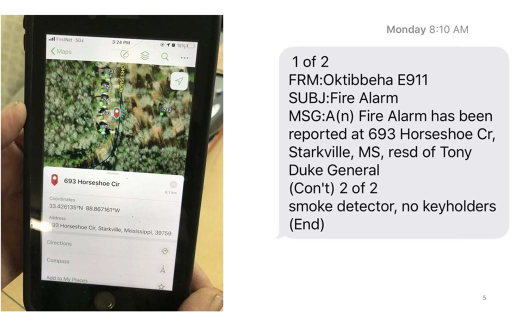
When a fire call is broadcast to the county fire department, the address and nature of the call is dispatched through both voice message by radio and by text message to mobile phones via the E911 Centre. Obviously, the voice message tells all firefighters the basic information which they need to know, but sometimes it can suffer from imperfect reception due to radio limitations, ambient noise or simple misunderstanding on the part of the recipient. The text message reiterates the address and nature of the call as well as presenting several features, data and capabilities.
Numeric system
All Oktibbeha County street or road addresses and locations of possible interest use a one to five digit number in addition to the road name. The numbers simply tell how far it is, in miles, from where the road starts to the address of interest.
This standard numbering system goes from south to north and west to east – for example, 7671 Webster Street is located 7.671 miles from where it starts. So by using this numeric system, a responder can be directed to within 5.28ft of the destination – and the database can also tell them, until intersecting the road of interest, to turn left or right to arrive at the address.
In turn, a separate database is available for personnel who have a GPS unit in their vehicle, that is specific to Oktibbeha County. The user can input either the road name or the numeric code and, if the road name is entered, the database will start listing addresses – when the desired location is found, the appropriate directions are given from the firefighter’s present location to that address.
If the numeric code is entered, all addresses in the county that have that code are displayed and the user simply selects the one that matches the desired road name. Then step by step, the driving directions are displayed. This is beneficial when en route, as a driver can quickly choose the correct location with one quick entry, while the firefighter does not have to worry about spelling the road name correctly. In the county there are several roads with names that are similar in terms of sound and spelling.
Further to this, there are east and west portions of the same road name, but the displayed numbers will not only show the match to the entered number, but also note if it is the north, south, east or west section of the road name. As the present numbering system is relatively new to the county and not everyone has posted the new address number on their property, both the old and new address numbers are shown on the display screen.
An excited phone caller may give their old address instead of the new one, although the enhanced E911 system should display the location of the call. If it’s from a landline it’s simple to access the street address and name of the caller. Mobile phone positions may be determined, but it takes some time to do so (see Figure 1 below).
.jpg)
The initial screen on a mobile phone simply defines the nature of the call (whether it is a fire, medical emergency or road traffic accident, for example), as well as the address. A tap on the screen provides an overview map of the location, while another tap provides an actual route to the location, complete with travel time. Additional taps give not only driving directions from the firefighter’s starting location (which may not be from home), but also an actual photograph of the property at that location.
While this photograph does not show smoke, it does show the configuration of any driveway and access route, as well as the general layout of the property (see Figures 2,3 and 4 below).


Water supplies
While there are a few fire hydrants in the county, along with some overhead storage tanks that are capable of quickly refilling a tanker, the static water supplies such as ponds, lakes and even those with dry hydrants take time and personnel to utilise (see Figure 5 below).

The E911 centre can send additional texts relating to the locations (addresses and GPS data) of appropriate water supplies near the fire.
These may be fire hydrants, water tanks, dry hydrants and/or static sources of water such as ponds, lakes and streams. Once again, picking the location of interest will provide driving directions. Obviously, the capacity of water tanks is known and the flow capacity of fire hydrants is tested and listed, while the properties of static water supplies are evaluated.
The Soil Conservation Service certifies such static sources as being year round supplies, with the access points designated (see Figure 6 below). As well as the locations of these water sources, there are additional facts relating to the type of water supply, capacity and fittings. The available water flow rates and volume capacity are in the database, while some sources have photographs or maps displayed. These static water supplies must be inspected and tested periodically to ensure compliance with standards and for operational capability.
.jpg)
For example, a dry hydrant must be flushed at least annually, as turtle eggs get through strainers, with growing turtles stopping up the piping. The overhead storage tanks are equipped with electric heaters to prevent freezing and have level indicators that are easily observable (there have been cases in which tanks have bullet holes, which over a long period of time cause them to drain). Any valves in these installations are locked (see flow test information in Figure 7 below).

Knowing the capacity of these water sources is of interest in that the closest source may not be adequate or appropriate for the tanker responding. For example, a large 3,000 gallon (11,400 litre) tanker needs a better driveway or turning radius than a smaller appliance. By using this location and delivery data, an adequate amount of water may be safely delivered to a fire site while adhering to the rules of the Mississippi State Fire Rating Bureau.
This Bureau regulates personnel levels, training levels, types and numbers of fire appliances, water tank construction and sizes, and other criteria which in turn determine fire insurance rates. A minimum of 500 gallons per minute (1,900 litres per minute) for an hour is required for these lower rates, if a total of 30,000 gallons (114,000 litres) is to be delivered.
All seven fire departments in Oktibbeha 58 and a population of about 25,000 work together to ensure good fire protection and low fire insurance rates. As a result of this combination of personnel, fire appliances and a detailed database of directions and resources, the departments are continuing to provide emergency services promptly and safely
Kirk Rosenhan is fire services coordinator for Oktibbeha County